
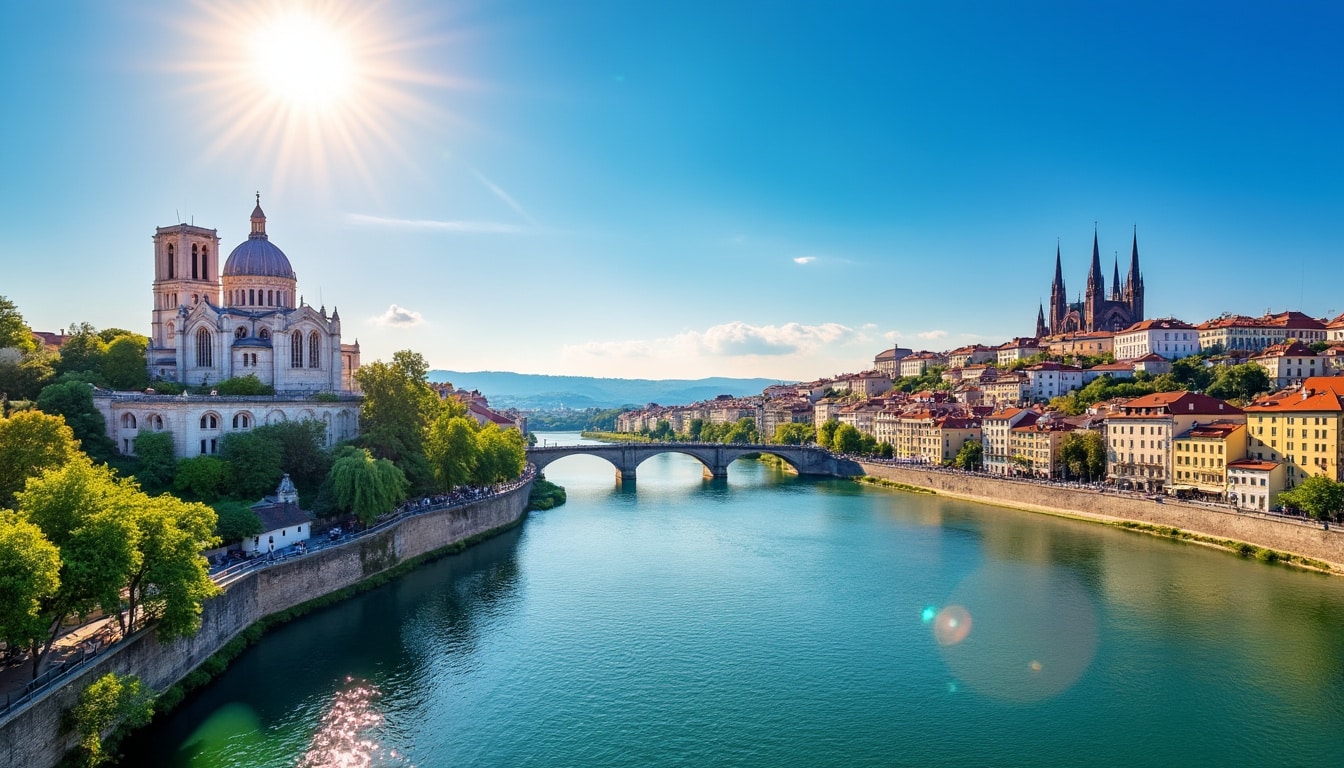
Nestled in the heart of France, Lyon is a city renowned for its vibrant culture, exquisite cuisine, and fascinating history. Situated precisely at the junction of the Rhône and Saône rivers, Lyon stands as a beacon of geographic and cultural significance. This lively metropolis is not only a culinary hub but also a critical node in the world of geolocation and travel. As travelers seek to explore this part of Europe, understanding Lyon’s coordinates and location becomes essential for navigation, tourism, and urban exploration.
Exploring Lyon’s Latitude and Longitude: A Geographical Overview
Lyon’s exact location is captured by its latitude and longitude, which are pivotal for geolocation services and mapping. The city is positioned at a latitude of 45.76 degrees North and a longitude of 4.835 degrees East. These coordinates place Lyon in the east-central region of France, solidifying its role as a gateway between northern and southern Europe.
Understanding these geographic coordinates not only aids in precise navigation but also provides a framework for many aspects of urban planning and smart city development. Lyon’s location plays a crucial role in its climate, cultural interactions, and socio-economic dynamics.
Lyon’s Strategic Position in Europe
Lyon’s coordinates reveal its strategic positioning within Europe. Situated approximately 470 kilometers from Paris and 320 kilometers from Marseille, it serves as a vital junction for intra-European travel. Additionally, its proximity to cities such as Geneva (160 km), Strasbourg (420 km), and even Turin, Italy (280 km), further accentuates Lyon’s importance on the continent’s map.
- 🎯 Paris: 470 km
- 🎯 Marseille: 320 km
- 🎯 Strasbourg: 420 km
- 🎯 Geneva: 160 km
- 🎯 Turin: 280 km
These connections are further facilitated by an extensive infrastructure network that includes motorways, rail lines, and air travel routes. Lyon’s geographical location makes it a bustling hub not just for business but also for leisure travelers seeking to traverse Europe with ease.
Navigating Lyon with Advanced Geolocation Tools
In today’s era of smartphones and advanced geolocation technology, navigating a city like Lyon has never been easier. Maps and GPS devices rely heavily on the city’s precise coordinates to offer accurate and efficient guidance. This technology is indispensable for travelers and locals alike, facilitating smooth travel experiences and efficient urban navigation.
In 2025, geolocation services in Lyon have reached sophisticated levels of accuracy. These include apps that provide real-time traffic updates, pedestrian navigation for tourists exploring the city’s historical sites, and public transportation planning for commuters.
Innovative Mapping Solutions in Lyon
Lyon has adopted innovative mapping solutions such as real-time traffic management platforms and interactive city maps. These tools not only help users find the quickest routes but also enhance their experience by integrating tourism insights and local tips. Maps of Lyon offer comprehensive details about the city’s landmarks, from the Basilica of Notre-Dame de Fourvière to the picturesque Vieux Lyon.
Let’s explore some must-see places that your map might direct you to:
- 🏰 Basilica of Notre-Dame de Fourvière: A stunning example of Lyon’s religious architecture.
- 👨🎓 University of Lyon: A key institution in the city’s educational landscape.
- 🎨 Musée des Confluences: Offering an array of anthropological and scientific exhibits.
Lyon’s commitment to blending technology with traveling enriches visitors’ experiences, transforming a navigational tool into a personalized guide through the city’s rich tapestry of history, culture, and urban development.
The Role of Coordinates in Lyon’s Urban Planning and Architecture
Lyon’s location and its geographic coordinates have a profound impact on the city’s urban planning and architectural layout. These elements are critical when designing new infrastructures, considering flood zones due to its proximity to rivers, and managing urban density.
Modern urban planning in Lyon incorporates geographic data to maximize land use efficiency, optimize public transportation networks, and enhance the quality of life for residents. Urban planners consider Lyon’s geographic and topographic aspects to design an environment that accommodates growth while preserving the city’s historic charm.
Architectural Highlights in Lyon
The architectural fabric of Lyon is a testament to its historical and environmental context. From the Roman amphitheater in Fourvière to the contemporary Confluence district, each building tells a story of the city’s evolving architectural dialogue.
Lyon’s architecture reflects diverse styles and influences:
- 🏛️ Roman Heritage: Ancient structures such as the Amphitheater highlight the city’s historical significance.
- 🏢 Modern Developments: The Confluence district showcases sustainable urban development.
- 🏠 Renaissance Buildings: A walk through Vieux Lyon unveils the rich architectural history from the Renaissance period.
Each of these structures is meticulously planned, considering the geographic constraints and opportunities presented by Lyon’s coordinates. This results in an urban landscape that harmoniously blends the old with the new, shaping Lyon’s identity as a city steeped in history yet forward-looking.
Lyon’s Coordinates and the Smart City Initiative
As Lyon embraces its role as a smart city, its geographic coordinates play a vital role in deploying and managing technological advancements. The smart city initiative aims to improve municipal services, boost connectivity, and foster sustainable development, all guided by precise geolocation data.
The city’s geographic location aids in deploying IoT (Internet of Things) devices for efficient energy use, monitoring environmental conditions, and enhancing public safety. These technologies rely on Lyon’s coordinates to function optimally, providing accurate data for urban management systems.
Smart City Benefits in Lyon
By integrating smart technologies, Lyon enhances its urban living conditions in various ways:
- 🌿 Sustainable Energy: Implementation of smart grids to conserve energy and reduce carbon footprint.
- 🚍 Public Transport Efficiency: Real-time updates and route optimization for seamless travel.
- 🌐 Digital Connectivity: Broadband access across the city supports digital services and innovation.
The use of geographic data in these smart applications ensures that the initiatives are tailored to the city’s specific needs and context, exemplifying the critical role of Lyon’s location in its transformation into a modern, intelligent urban space.
Geolocation as a Catalyst for Tourism in Lyon
Lyon’s location and iconic coordinates make it a key destination for tourists from around the world. The city’s unique blend of history, gastronomy, and modern innovation draws visitors eager to explore its vibrant streets and cultural offerings. Its coordinates are not only numbers but a symbol of the city’s accessibility and appeal.
Tourism in Lyon is enriched by the convenience of modern geolocation services, which allow visitors to effortlessly discover attractions, dining experiences, and events throughout the city.
Must-Visit Spots in Lyon for Tourists
Here are some highlights that are a must-see for anyone exploring Lyon:
- 🎡 Place Bellecour: One of the largest open squares in Europe, perfect for a leisurely stroll.
- 🏟️ Stade de Gerland: A piece of sports history with its rich legacy.
- 🌯 Lyon’s Bouchons: Experience traditional Lyonnais cuisine in these cozy eateries.
Lyon’s strategic location, rich history, and modern advancements provide an irresistible combination for tourists. The seamless integration of geolocation technology enhances the travel experience, making navigation simpler and more enriching than ever before.
Lyon’s Gastronomic Scene
A visit to Lyon is incomplete without indulging in its renowned culinary offerings. As the gastronomic capital of France, Lyon offers a feast for the senses with a wide range of delicious dishes and traditional cuisines that reflect its rich heritage and modern innovation.
| Dish | Description |
|---|---|
| Quenelle | A delicate dumpling traditionally made from pike fish. |
| Saucisson sec | A flavorful dried sausage, often enjoyed as an appetizer. |
| Salade Lyonnaise | A hearty salad with frisée lettuce, crispy bacon, and a poached egg. |
FAQ
How can I navigate Lyon using public transport?
Utilize the comprehensive network of buses, trams, and the metro, all optimized by Lyon’s advanced geolocation technologies.
What makes Lyon a strategic European hub?
Its central location and extensive transport connections make it an ideal gateway for traveling across Europe.
Can geolocation services enhance my visit to historical sites in Lyon?
Absolutely, these services provide historical insights and navigation assistance for an enriched cultural experience.
How does Lyon’s architecture reflect its history?
The city boasts a mix of Roman, Renaissance, and modern architectural landmarks that narrate Lyon’s historical evolution.
What culinary delights should I try in Lyon?
Don’t miss out on traditional dishes like quenelle, saucisson sec, and salade Lyonnaise, which offer a taste of Lyon’s rich culinary heritage.
In conclusion, the coordinates and location of Lyon are more than just geographical markers; they are key to its identity as a thriving urban center. The city’s strategic placement, bolstered by innovative navigation technologies and smart city initiatives, continues to attract visitors, enhance residents’ quality of life, and preserve its rich cultural and architectural legacy.

Lyon, a vibrant city at the confluence of the Rhône and Saône rivers, offers much more than its gastronomic and historical fame. Brimming with natural beauty and rich geography, it serves as an intriguing subject for exploration. From its verdant…

Known for its vibrant cultural heritage and breathtaking architecture, Lyon is a city that offers much more than its famed cuisine. Nestled in the heart of the Rhône-Alpes region in France, Lyon’s geography offers an intriguing blend of rivers, hills,…

Discover the enchanting natural beauty of Lyon, a city that seamlessly blends historical charm with stunning natural landscapes. From vast urban parks to tranquil riverbanks, Lyon offers a plethora of nature spots that are perfect for all kinds of outdoor…

Nestled in the heart of France, Lyon is a city known for its vibrant history, gastronomic delights, and enchanting waterways. The intersection of the mighty Rhône and the gentle Saône rivers has shaped Lyon’s cultural and economic tapestry for centuries.…